| Beach access | possible, but leads through an open building site |
|---|---|
| Signage | in place (“Public Beach Access”), but with no recognisable authority details |
| Surface of the path | gravel and earth, dusty; no sealed surface |
| Restaurant / bungalows | demolished, closed since around 2023/24 |
| Toilets / showers | none |
| Shade / sunbeds / rentals | none |
| Snorkelling | very good – reef right off the shore |
| Arriving by kayak | possible, boats lie on the beach |
| Parking | a few spaces on the road above, tight |
| Entrance fee / lifeguards | none / none |
Some beaches change slowly. Ao Sane Beach is not one of them. The little cove just north of Nai Harn was for years the insider tip for anyone who wanted to reach a reef without a boat: three tiny sandy coves, granite boulders, clear water, a few wooden bungalows under the trees and a beach restaurant where you could sit for hours.
What is left of the service is: nothing. What has not gone is the water, the rocks, the reef. If you work your way along the beaches of Phuket, you quickly notice: no other cove has an approach like this one.
From the beach the cove looks almost unchanged: coarse sand, massive granite boulders, a shallow channel between them where the water runs up when there is a swell, and a view north to the green coast with the wind turbine on the hill. The real treasure lies under water – the coral gardens begin a few metres from the shore. If you snorkel, follow the rock line to the right, that is northwards; that is where the underwater landscape is densest, at two to five metres. What you need for it is listed under practical information below.
The price for this is the location: for several years there has been construction above the cove and partly directly behind the beach. The old bungalows and the restaurant have been demolished, there are no toilets, no showers, no shade, no sunbeds, no drinks for sale. Apart from that, the cove is still there as it was.
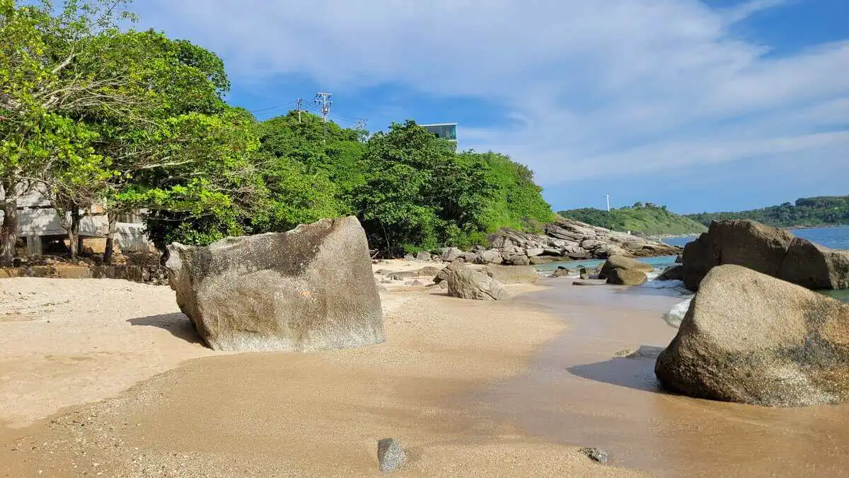
Two perspectives on the same cove, and they show the contrast well: one looking south, where the coarse sand opens into a wide flat area and the waves run out shallowly – and one looking back, where the ruin stands between old trees, its concrete slab reaching almost to the sand.


Important for navigation: map apps route you in as a public road, although it runs across private land. Do not rely on the map route, rely on the description above. If you meet security or barriers, do not argue – take the coastal path from Nai Harn instead.
By scooter the approach is straightforward – how to get around the island on two wheels in general is covered under scooter hire in Phuket. By car you need dry weather, steady nerves and luck with the few parking spaces on the narrow road above the cove – there is a partial parking ban there, with fines.
At the fork stands a large, cleanly printed direction sign: “Public Beach Access”, “Ao Sane Beach” and “Krating Cape”, all three with an arrow and “350 m”, plus a small sketch map with a red dot marked “You are here”. Alongside it a brown resort sign (“Baan Krating Resort 200 m”) and a red-and-white “Do not litter”.
That is more than you find at most beach entrances in Phuket – the sign even contradicts the widespread assumption that the access is being deliberately obscured. Two reservations remain:
Our advice: take the sign as confirmation that the way is signposted as a public beach access – but do not count on being able to pass without difficulty on a weekday.

Our own impression, deliberately worded as an observation: there are two separate building operations – one on the slope above, a second directly behind the beach – and no continuous barrier in the area between them. Whether you are passing a building site or a public path is not discernible. We parked on the road above and walked down.
Directly behind the beach there is a concrete slab with a retaining wall that reaches into the beach area; rusty reinforcement bars stick out of it, and the remains of a hammock or swing hang under the trees. We saw no fences, no barrier tape and no warning signs – nor any construction workers.
It is clearest at the point where you walk back up from the beach: on the left a freshly graded narrow earth path between the trees, on the right two raw, unrendered concrete structures with open window openings, with rubble and cast-in foundations between them. None of it is cordoned off – the path runs straight through. As a visitor you cannot tell whether this is a public passage, a route for construction vehicles or simply a building plot entered unlawfully.
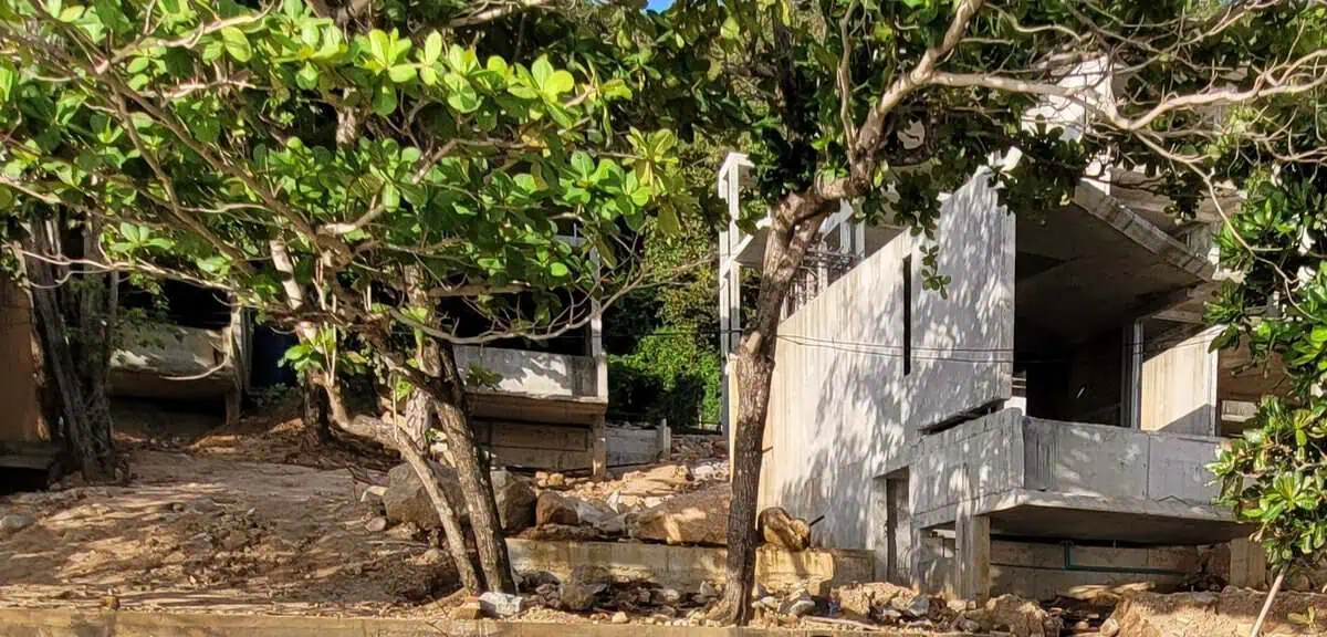
This is the most telling picture of the day: it shows not only that building is going on, but what the approach to the beach currently looks like – a passage through an open building site.
This is a Sunday snapshot: no site fences, no security staff, no work in progress. On a weekday the same spot may look quite different. If you take the path, you do so at your own risk; visitors have no business in the active construction area itself.

Not legal advice, not an allegation: whether the building work is permissible in this form we cannot judge from the outside – that would require checking the building permit, required setbacks and property boundaries. What stands out is the history: for the villas on the hill above, the municipality already issued stop-work orders and demolition orders in 2017 and 2019 because the pool, balconies and setbacks did not match the approved plans; in 2018 the forestry authorities also established that more than 30 rai of protected forest in the Ao Sane area had been occupied. None of that follows automatically for today's construction – but it explains why the beach has been an issue for years.
A widespread misunderstanding: Ao Sane Beach is not a sunset beach. The cove does open to the west, but the ridge behind it takes the sun away before it reaches the sea. In our photo taken at 16:55 the sun is still high above the water – an hour later it disappears behind the slope. You see the sky colour and the water glitter, but you do not see the sun dip into the sea.
If you want the full picture, walk on to the Laem Krating viewpoint or drive the few minutes to Promthep Cape. An overview of all the suitable spots is in our guide to the viewpoints in Phuket.

The most elegant solution to the access problem: don't drive, paddle. Kayaks and SUPs are available for hire at Nai Harn, Yanui and Rawai; from Nai Harn it is about 20 to 30 minutes to the cove in calm seas. You land directly on the beach – and beaches in Thailand are public, so the detour across private land disappears completely. That it works in practice is shown by the sand: on our visit a hired double kayak was lying on the shore.


| Best time | 8–11 am: calm water, good light, no construction work |
|---|---|
| Season | November to April (dry season); often murky and unsettled in the rainy season |
| Time needed | 2–3 hours including snorkelling |
| Kit | water shoes (rocks, sea urchins), your own snorkel set, drinking water, sun protection |
| Reef protection | do not stand on coral, no gloves, sunscreen without octocrylene |
| Step-free access | no – gravel path, slope, rock, no handrail |
| Cost | no entrance fee; parking free but scarce |
For snorkellers: yes, with reservations – the reef is the reason to come, not the beach. For families, sunbathers and anyone expecting service: no, you are better off at Nai Harn, Yanui or one of the other beaches on the west coast. If you know the way and know what to expect, you get one of the best underwater landscapes on the island – just without the setting that used to make it so pleasant.
Sources and status
Read next: all beaches in Phuket at a glance · all beaches in one comparison table · Ao Sane Strand (Deutsch)
This page contains no legal assessment of the building work. Observations are marked as such and dated. Prices, conditions and access can change at any time.